twnoaa 📡🛰️
twnoaa is an all-in-one desktop application for automated weather satellite pass tracking, RTL-SDR radio reception, real-time DSP demodulation, multi-format satellite image decoding, and multimodal AI-powered meteorological analysis. Built with Wails, Svelte 5, and Go. Part of the TWSNMP project family.
🗺️ System Workflow & Architecture
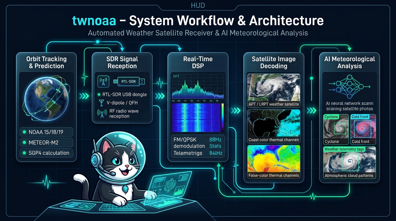
twnoaa integrates the full satellite reception pipeline: from SGP4 Orbit Tracking to RTL-SDR signal capture, real-time DSP (FFT Spectrum & Waterfall), multi-format image decoding, and automated multimodal AI meteorological analysis.
✨ Key Features
- 🛰️ Automated Orbit Propagation & Pass Prediction — Built-in pure Go SGP4 engine fetches live TLEs from CelesTrak to calculate precise visible satellite passes and auto-schedule receptions based on observer coordinates.
- 📻 Direct RTL-SDR Control & Real-Time DSP — Direct hardware control via
librtlsdr, including Bias-Tee power (4.5V for active LNAs), dynamic gain tuning, and live high-speed FFT spectrum & waterfall displays. - 🧪 Built-in Simulation Mode — Full workflow verification (synthetic signal generation, DSP demodulation, APT image synthesis, AI analysis) even without physical SDR hardware connected.
- 🖼️ Multi-Protocol Satellite Decoders
- NOAA APT: FM demodulation, 2400 Hz AM subcarrier sync frame cross-correlation, dual-channel (Visible & Thermal IR) high-resolution image rendering.
- METEOR-M2 LRPT: QPSK demodulation, Costas loop carrier recovery, RRC matched filtering, Viterbi & Reed-Solomon error correction for high-resolution multispectral imagery (with resilient timestamp outlier handling & automatic clock fallback).
- SSTV: ISS (International Space Station) and amateur radio space image decoding (Martin, Scottie, and other modes).
- 📡 ISS APRS Packet Telemetry & Real-Time Monitor — Dual-branch demodulation of 1200 bps AFSK / AX.25 packets from the International Space Station (ARISS), featuring live callsign tracking, Maidenhead Grid Locator resolution, and one-click Google Maps / aprs.fi integration.
- 🤖 AI Meteorological Insights & Cat Animation — Passes newly decoded satellite images and reception metadata to Multimodal LLMs (Google Gemini, OpenAI, Anthropic, or local Ollama) to produce weather front, cyclone vortex, and cloud pattern analysis, accompanied by a delightful animated cat character during reasoning.
- 📼 Raw I/Q Data Recording & Replay — Capture live raw RF signals to disk and replay them anytime with different filter parameters or decoder algorithms.
- 💾 Local-First Persistent Storage — Embedded bbolt key-value database securely stores all pass records, decoded images, and AI reports completely on your local machine.
- 🌐 Bilingual UI — Seamless switching between English and Japanese interfaces.
🛠️ Hardware Requirements
To receive signals from orbiting weather satellites and decode high-definition imagery, the following hardware setup is recommended:
1. SDR Receiver (Software Defined Radio)
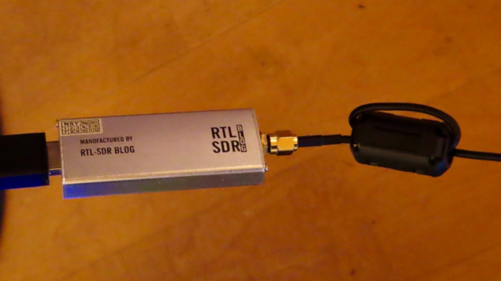
- Recommended Model: RTL-SDR Blog V3 / V4
- Interface: USB 2.0 / 3.0
- Features:
- High sensitivity in the 137 MHz VHF weather satellite band.
- Built-in Software-Switchable Bias-Tee (4.5V DC): Power your active low-noise amplifier (LNA) directly through the coaxial cable with a single click in twnoaa—no external DC power injectors or extra power cables required.
2. Receiving Antenna
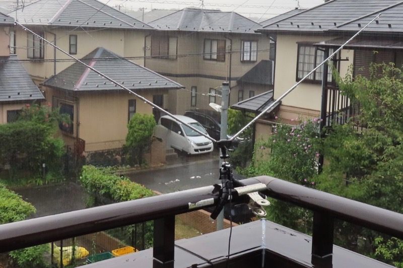
Example of a 120° V-dipole antenna mounted on a balcony railing using a clamp fixture
- V-Dipole Antenna:
- Element length for 137 MHz: ~53.4 cm per element (~107 cm total tip-to-tip)
- Angle: ~120° V-shape mounted horizontally
- Cost-effective, easy to build or purchase as a kit, and highly effective for overhead satellite passes.
- QFH Antenna (Quadrifilar Helix):
- Omnidirectional circular polarization (RHCP) antenna designed specifically for polar-orbiting satellites, offering balanced reception gain from low elevation up to zenith.
- Turnstile Antenna (Crossed Dipole):
- Omnidirectional 90° phased circular-polarization antenna.
3. LNA (Low Noise Amplifier) & Bandpass Filter
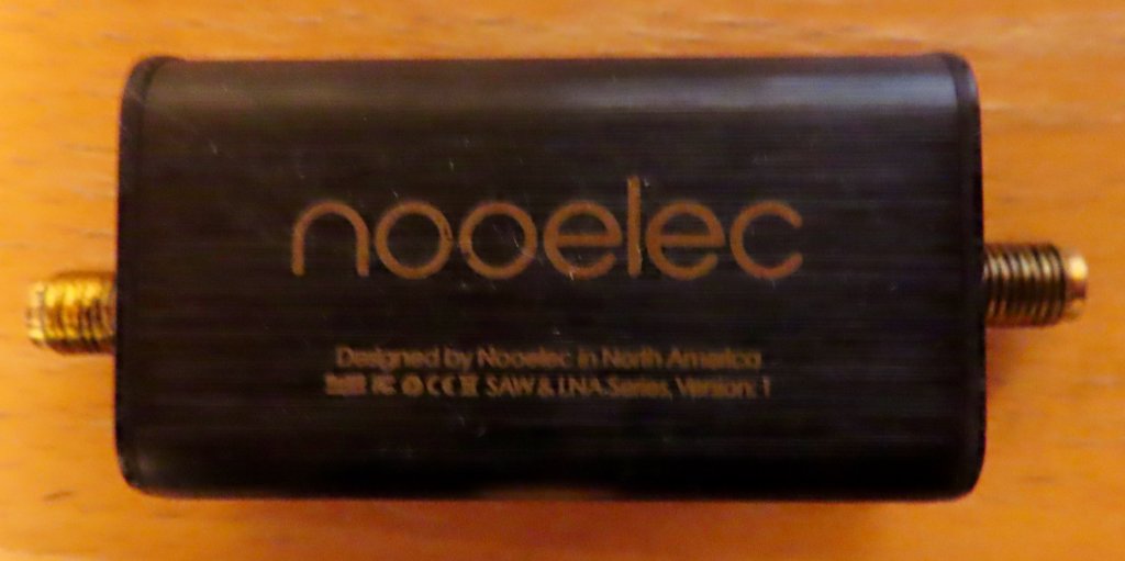
Nooelec SAWbird+ NOAA LNA module (inline SMA coaxial cabling, powered via Bias-Tee)
- Recommended Model: Nooelec SAWbird+ NOAA or RTL-SDR Blog Wideband / Filtered LNA
- Weather satellite signals arrive from ~850 km in space with very low power. An LNA placed near the antenna provides high gain (~30 dB) with an ultra-low noise figure, while the built-in SAW filter rejects strong out-of-band interference (FM broadcast 76–108 MHz, cellular, and land mobile radios).
- Powering: Automatically powered via coaxial cable by turning on the Bias-Tee switch in twnoaa.
4. Coaxial Cable & Connectors
- 50 Ω low-loss coaxial cable (RG58, 3D-2V, LMR-195/200, etc., with SMA connectors).
📡 Antenna Installation & LNA Connection Guide
Because satellite RF signals are very faint, proper antenna placement and LNA cabling order are critical for clear, snow-free imagery.
Antenna Placement
- Clear Line of Sight:
- Install the antenna in an open location with an unobstructed view of the sky (e.g., roof, balcony railing, or garden mast).
- Nearby buildings, dense trees, metal fences, and power lines attenuate VHF signals and introduce sync dropouts.
- V-Dipole Orientation:
- Keep the V-shaped element plane horizontal (parallel to the ground), and orient the opening of the V pointing True North and True South (since weather satellites travel in near-polar North-South orbits).
LNA Connection Sequence
[!IMPORTANT] Always connect the LNA directly at the antenna feedpoint (before long cable runs)!
[Antenna] ──(Short jumper cable)──> [LNA Input] ──> [LNA Output] ──(Long Coax Cable)──> [RTL-SDR Dongle] ──> [Host PC]
- Why place the LNA near the antenna? If the LNA is placed at the indoor end of a long coaxial cable, both the attenuated satellite signal and the noise picked up along the cable run will be amplified together, resulting in poor Signal-to-Noise Ratio (SNR). Amplifying the pure, un-attenuated signal right at the antenna preserves the best possible SNR.
- Weatherproofing: Enclose outdoor LNAs in a weatherproof junction box and wrap all outdoor RF connectors with self-amalgamating waterproof tape.
- Activating Bias-Tee: Toggle the Bias-Tee switch to ON in twnoaa’s SDR control panel to supply 4.5V DC to the LNA through the coaxial line (confirm that the LNA power LED lights up).
🖥️ User Interface & Operation Guide
twnoaa features a streamlined tabbed layout for tracking, receiving, and analyzing satellite imagery.
1. Pass Tracker (Live Satellite Sky Watch)
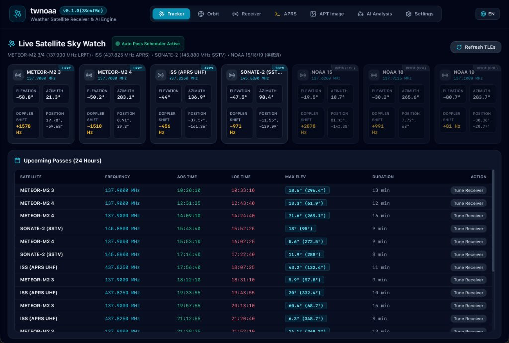
- Live Satellite Sky Watch:
- Displays real-time elevation, azimuth, Doppler frequency shift, and geographic coordinates for tracked satellites (METEOR-M2 3/4, NOAA 15/18/19, ISS, SONATE-2).
- Status badges indicate active passes (“Auto Pass Scheduler Active”).
- Upcoming Passes (24 Hours):
- Fetches live orbital TLE data from CelesTrak (with a manual “Refresh TLEs” button) and computes passes with Acquisition of Signal (AOS), Loss of Signal (LOS), Maximum Elevation (MEL), and duration.
- Clicking “Tune Receiver” automatically transfers the target frequency and demodulator settings to the SDR receiver. Passes with MEL > 20° typically provide excellent reception.
2. 3D Globe View (Orbit)
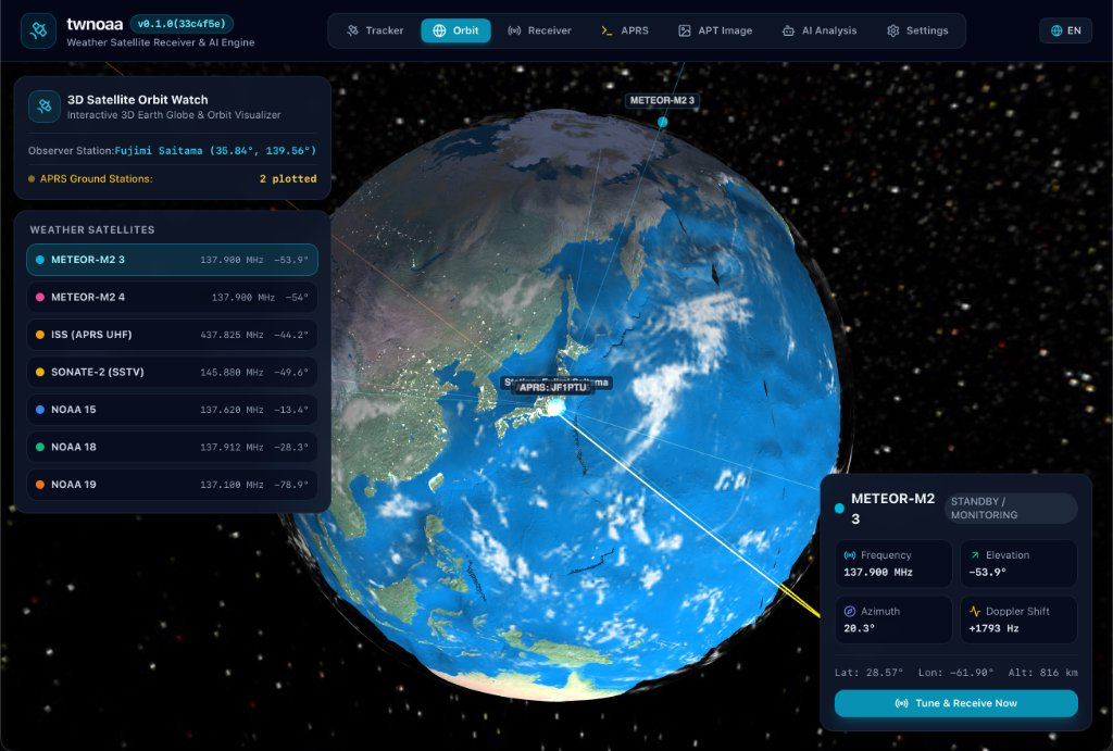
- 3D Satellite Orbit Watch:
- Interactive 3D Earth globe visualizer rendering real-time satellite positions and orbital flight paths for all active weather satellites.
- Draws a live vector beam from your ground station to in-range satellites, helping you visualize the arrival vector of the incoming RF signal.
- 3D APRS Ground Station Mapping:
- Automatically extracts geographic coordinates from received APRS packets and plots active ground stations and beacons directly onto the 3D globe surface with real-time station counts.
- Satellite Telemetry Card:
- Selecting a satellite displays its center frequency, real-time elevation, azimuth, Doppler frequency shift, sub-satellite coordinates (latitude/longitude), and flight altitude (Alt).
- Status indicators show “STANDBY / MONITORING” or incoming pass alerts, with a “Tune & Receive Now” shortcut button to jump straight into reception.
3. SDR Reception Test & Spectrum (Receiver)
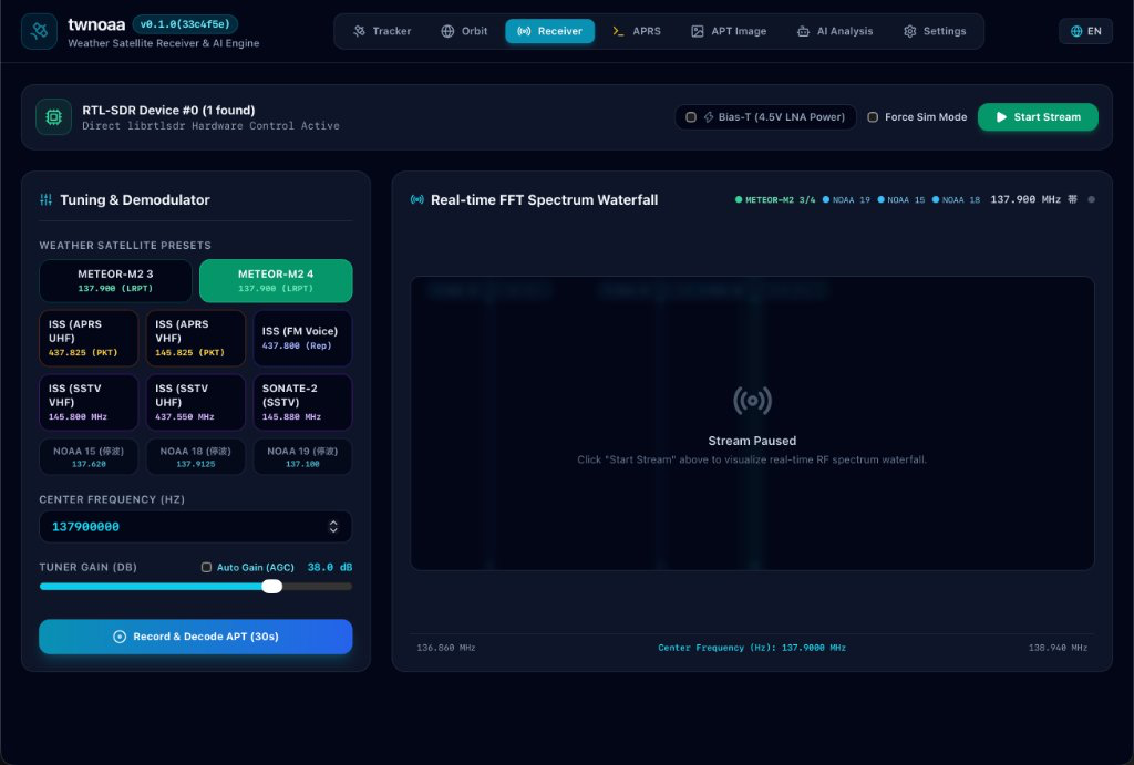
- Hardware Control Header:
- Displays detected RTL-SDR status (e.g.,
RTL-SDR Device #0 (1 found) Direct librtlsdr Hardware Control Active). - Bias-T (4.5V LNA Power): Power active LNA amplifiers through the coaxial cable with a single toggle.
- Force Sim Mode: Run internal synthetic signal generation without hardware connected.
- Start Stream / Stop Stream: Toggle live streaming I/Q processing.
- Displays detected RTL-SDR status (e.g.,
- Tuning & Demodulator Panel:
- Weather satellite quick-select presets (METEOR-M2 3/4, ISS, SONATE-2, NOAA 15/18/19).
- Center frequency adjustment, manual tuner gain slider, and Auto Gain (AGC).
- “Record & Decode APT (30s)” button and demodulation status indicator.
- Real-Time FFT Spectrum & Waterfall:
- Overlaid satellite frequency markers (METEOR-M2 3/4, NOAA 15/18/19, etc.) for visual Doppler monitoring and signal lock.
4. APRS Packet Monitor (APRS)
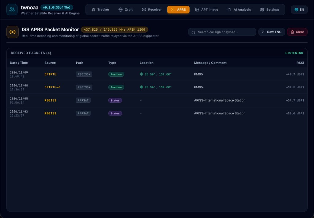
- Real-Time APRS Packet Stream:
- Decodes and logs incoming AX.25 1200 bps AFSK packets from the International Space Station (ARISS: 437.825 MHz / 145.825 MHz) and other satellites.
- Displays sender callsign (From), destination / digipeater path (To / Path), symbol icon, decoded message payload, timestamp, and signal level (RSSI).
- Maidenhead Grid Locator Parsing & Map Links:
- Automatically parses Maidenhead grid locators (e.g.
PM96) embedded in packet payloads into latitude/longitude coordinates. - Includes a direct “Map” button to open the sending station’s geographic position on Google Maps or aprs.fi in your browser.
- Automatically parses Maidenhead grid locators (e.g.
- Search Filtering & Clean Interface:
- Incremental text filtering by callsign or content, auto-scroll toggle, and one-click log clearing.
5. Satellite Image Gallery (Image Gallery)
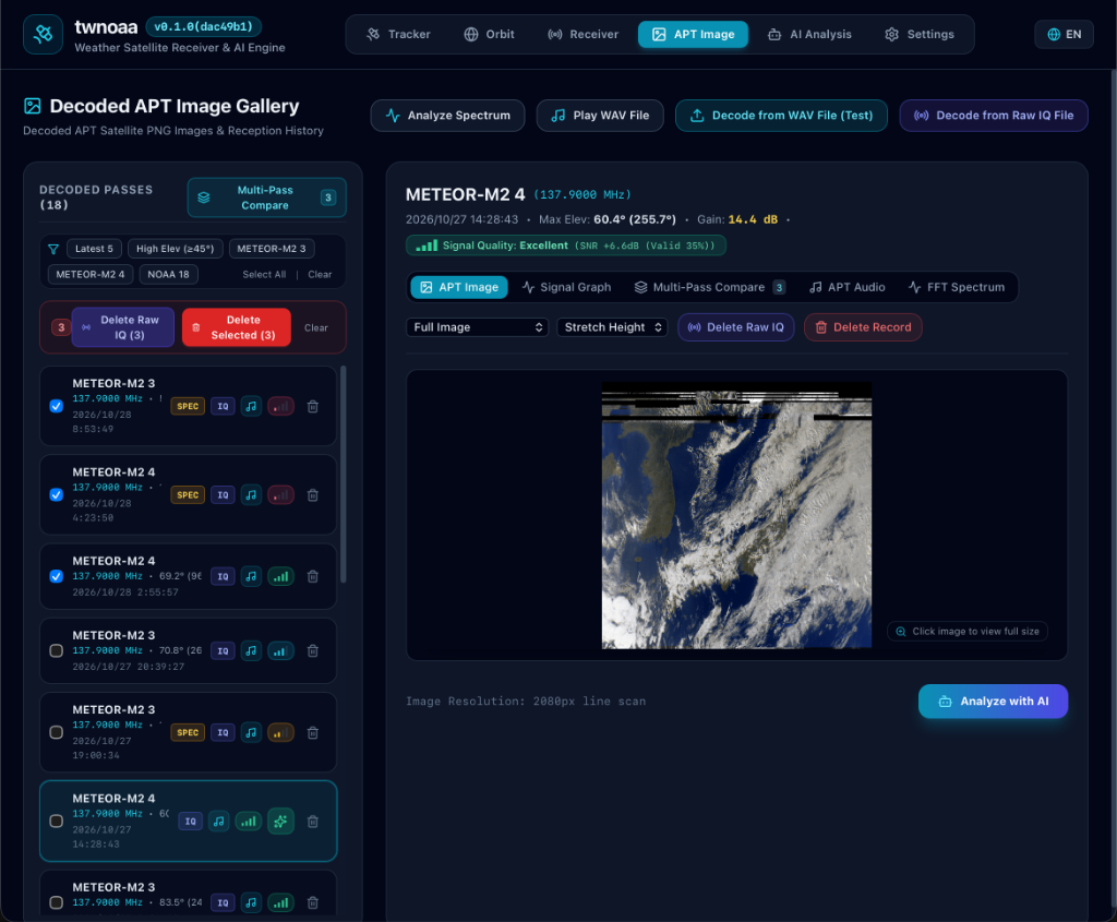
- Decoded Pass History & Filters:
- Lists all received and decoded satellite passes with timestamps, frequencies, Max Elevation, SNR stats, and data badges (IQ raw signals, demodulated audio).
- Quick filters for recent passes (“Latest 5”), high-elevation passes (“High Elev (≥45°)”), specific satellites, or “Multi-Pass Compare”.
- High-Definition Image Viewer:
- Displays rendered multispectral and visible/IR satellite images. Clicking the preview launches a center-locked zoom & pan viewer for inspecting cloud vortices, frontal boundaries, and coastlines.
- Multi-tab visualization modes: “APT Image”, “Signal Graph”, “Multi-Pass Compare”, “APT Audio”, and “FFT Spectrum”.
- FM Voice Audio Playback & Per-Pass APRS Packet Log:
- Play back demodulated WAV audio for non-image transmissions, such as ISS cross-band FM repeater passes, directly within the UI.
- Inspect the full list of APRS packets received and decoded during each specific satellite pass session.
- Offline Processing & AI Handoff:
- Re-demodulate and re-decode historical raw signals offline via “Decode from Raw IQ File” or “Decode from WAV File (Test)”.
- One-click “Analyze with AI” sends the satellite image and pass telemetry directly to multimodal LLMs.
6. AI Meteorological Analysis (AI Analysis)
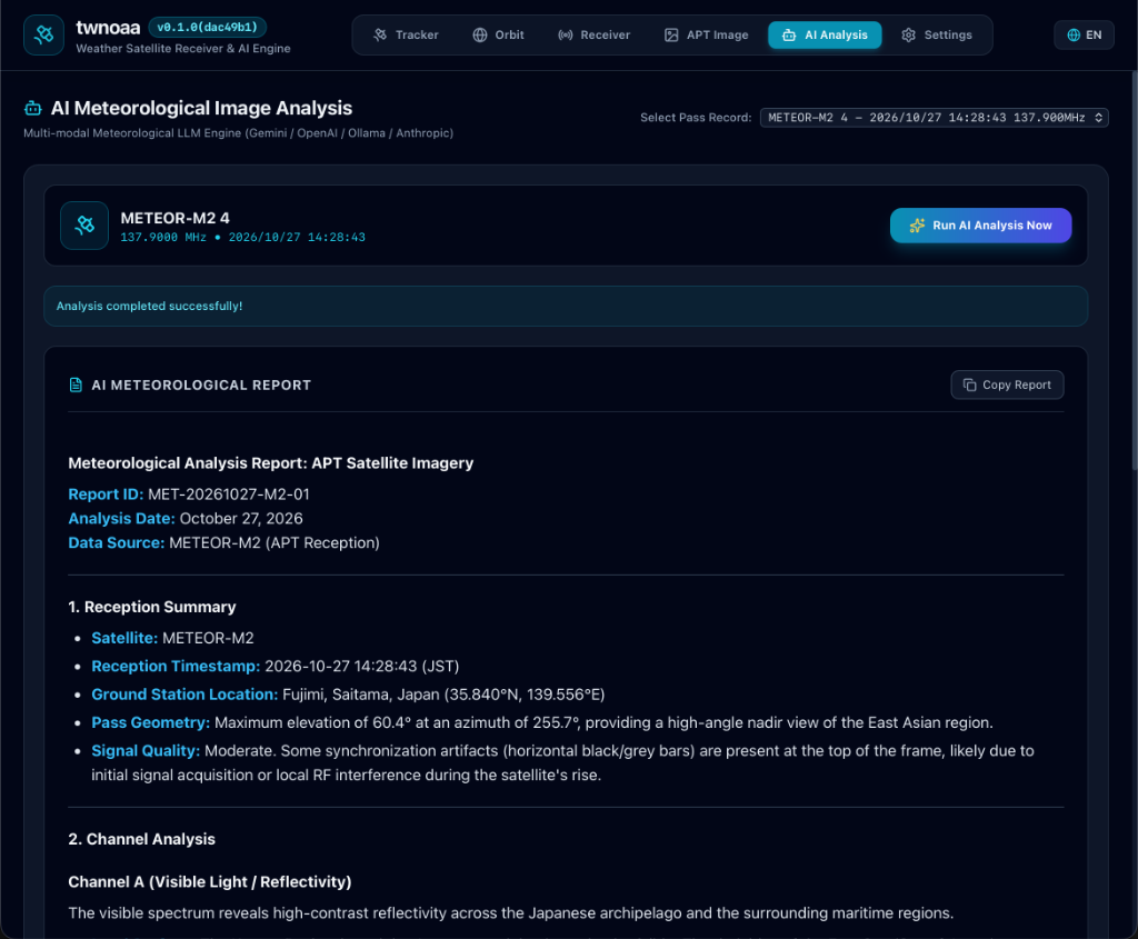
- Multi-LLM Weather Analysis Engine:
- Select any recorded satellite pass from the “Select Pass Record” dropdown and click “Run AI Analysis Now” to submit the decoded imagery and pass telemetry to multimodal models (Google Gemini, OpenAI, Ollama, or Anthropic).
- An animated detective cat mascot appears in a thinking modal while the AI engine generates insights.
- Structured Weather Intelligence Report:
- Automatically compiles a comprehensive meteorological assessment:
- Reception Summary: Target satellite, timestamp, ground station location, pass geometry (max elevation/azimuth), and signal quality diagnosis.
- Channel Analysis: Visible light reflectivity, cloud top temperatures, synoptic weather fronts, cyclonic vortex rotation, and typhoon structures.
- “Copy Report” button copies the formatted markdown report directly to your clipboard with one click.
- Automatically compiles a comprehensive meteorological assessment:
7. Settings

- Modern 2×2 Grid Layout:
- Application info, Ground Station coordinates, SDR Receiver settings, and AI/LLM providers organized in a clean 4-quadrant layout.
- Observer Location Coordinates:
- Ground station label, latitude (°N), longitude (°E), and altitude (km).
- One-click “autoLocation” button automatically detects station coordinates from IP address.
- SDR Receiver Configuration (
sdrConfig):- Auto-record Satellite Passes: Automatically triggers SDR tuning, reception, recording, and decoding when satellite elevation reaches 5° or higher.
- ISS Pass Mode: Choose auto-record preference when the ISS passes overhead (APRS, SSTV, or Voice).
- Bias-T (4.5V Coaxial Power): Supplies 4.5V DC power via antenna coaxial cable to power active LNAs like Nooelec SAWbird+ (RTL-SDR Blog V3/V4).
- Auto Record Duration & Gain Settings: Configure pass duration in seconds, manual gain, or Auto Tuner Gain (AGC).
- Save Raw IQ Stream Data (
.iq) & Storage: Real-time display of total saved raw signal storage space and file count, with a “Delete All Raw IQ Data” button for easy maintenance.
- LLM Provider Settings:
- Configure Google Gemini, OpenAI, Anthropic Claude, or local Ollama with API keys, models, and custom prompts.
- UI Language: Instant toggle between English and Japanese via the language icon in the top header.
🔍 Supported Satellites & Transmissions
| Target | Frequency | Mode / Modulation | Resolution / Details |
|---|---|---|---|
| NOAA 15 | 137.620 MHz | APT (FM / AM 2.4 kHz Subcarrier) | 4 km/px, 2-channel (Visible & Thermal IR) |
| NOAA 18 | 137.9125 MHz | APT (FM / AM 2.4 kHz Subcarrier) | 4 km/px, 2-channel (Visible & Thermal IR) |
| NOAA 19 | 137.100 MHz | APT (FM / AM 2.4 kHz Subcarrier) | 4 km/px, 2-channel (Visible & Thermal IR) |
| METEOR-M2-3/4 | 137.100 / 137.900 MHz | LRPT (72k/80k QPSK) | 1 km/px, Digital high-resolution multispectral |
| ISS (SSTV VHF) | 145.800 MHz | SSTV (FM / Various SSTV modes) | Space events & school contact picture transmissions |
| ISS (SSTV UHF) | 437.550 MHz | SSTV (FM / Various SSTV modes) | Recent UHF experimental SSTV transmissions |
| ISS (FM Voice) | 437.800 MHz | FM Voice (Cross-band Repeater Downlink) | Worldwide amateur contacts & astronaut downlink (145.990 MHz Up) |
| ISS (APRS UHF / VHF) | 437.825 / 145.825 MHz | AFSK 1200 / AX.25 Packets | Worldwide position beacons & short messages via ARISS |
🤖 AI Meteorological Analysis
When a satellite pass is completed and the image is decoded, the metadata (Satellite, Frequency, Timestamp, Maximum Elevation, Coordinates) is packaged with the image and submitted to the configured multimodal LLM:
- Synoptic Weather Analysis: Identification of low-pressure cyclonic vortices, cold/warm fronts, typhoon eye structures, and convective cloud bands.
- Landmass & Geographic Recognition: Detection of coastlines, peninsulas, islands, snow/ice cover, and sea surface temperature gradients.
- Structured Markdown Report: Clear, professional weather observations suitable for amateur radio satellite trackers.
Supported AI Providers
- Google Gemini (
gemini-2.5-flash,gemini-1.5-pro, etc.) - OpenAI (
gpt-4o,gpt-4o-mini, etc.) - Anthropic Claude (
claude-3-5-sonnet, etc.) - Ollama (Local models:
llava,minicpm-v, etc.)
🛠️ Tech Stack
| Component | Technology |
|---|---|
| Desktop Framework | Wails v2 |
| Backend | Go 1.27 + CGO (librtlsdr) |
| Frontend | Svelte 5 (Runes) + TypeScript + Tailwind CSS |
| Database | bbolt (Embedded Key-Value Store) |
| SDR / DSP | github.com/jpoirier/gortlsdr, Pure-Go DSP (WFM, QPSK, FFT, Envelope Extraction) |
| Orbit Engine | Pure-Go SGP4 propagation model + CelesTrak TLE client |
| AI Integration | langchaingo + Multimodal LLM providers |
| Packaging | macOS PKG (Apple Notarization), Windows ZIP, Linux tar.gz |
🚀 Installation & Releases
Download Prebuilt Packages
Visit the Releases page to get binaries for your operating system:
- macOS (Apple Silicon): Download
twnoaa-v0.2.0-darwin-arm64.pkgand run the signed installer (notarized by Apple; bundleslibrtlsdrandlibusbdynamic libraries so no separate installation is required). - Windows (x64): Download
twnoaa-windows-amd64.zip, extract to any directory, and runtwnoaa.exe(includes requiredrtlsdr.dll). - Linux (x64): Download
twnoaa-linux-amd64.tar.gz, extract and run (requireslibrtlsdr0,libwebkit2gtk-4.1-0).
💻 Development Setup
Prerequisites
- mise (Toolchain manager for Go and Node.js)
- Wails CLI v2.15+
- RTL-SDR library (
librtlsdr):- macOS:
brew install librtlsdr - Ubuntu/Debian:
sudo apt-get install -y librtlsdr-dev libgtk-3-dev libwebkit2gtk-4.1-dev - Windows: prebuilt 64-bit DLL & headers
- macOS:
Setup Dependencies
# Install Go and Node via mise
mise install

# Install frontend dependencies
cd frontend
npm install
cd ..
Live Development Mode
mise run dev
# or
wails dev
Production Build
# Local build
mise run build

# macOS signed and notarized installer package (.pkg)
mise run release-mac
🗄️ Data Directories
Configuration, pass logs, decoded images, and the bbolt database are stored locally in the following OS directories:
| Platform | Default Path |
|---|---|
| macOS | ~/Library/Application Support/twnoaa/ |
| Windows | %APPDATA%\twnoaa\ |
| Linux | ~/.config/twnoaa/ |